
Walking the Land are embarking on a woodland pilgrimage that will circle around the woodlands and forests of Gloucestershire, as part of this year’s site2011 festival, organised by Stroud Valleys Artspace.
Starting on Sunday 29th May, we walk from Folly Wood in Stroud to Tetbury and then over the following days until Friday 3rd June take in other woodlands around the county including the Arboretum at Westonbirt and over the Severn Bridge to the Forest of Dean. During the 100 miles, we’ll be working on our own projects that include a series of tree rubbings, taken every mile of our journey.
During the walk, we hope to keep updating our progress on these pages, showing maps, photographs and drawings.
On the afternoon of Friday 3rd (our First Friday Walk Day) we’re inviting participation from artists to join us on the last 10.25 stretch of the walk from Gloucester to our finish at Folly Wood. As it’s a demanding walk, you’ll need to be fit, well shod with proper walking boots and capable.
Day 1
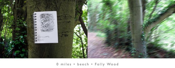
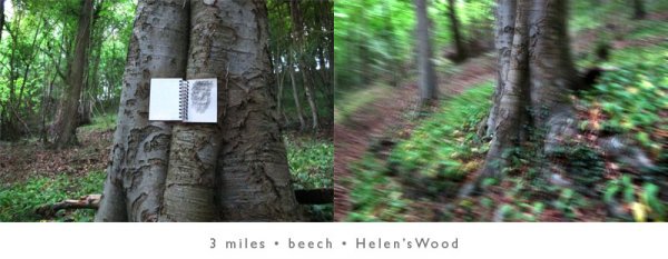
Folly Wood to Tetbury
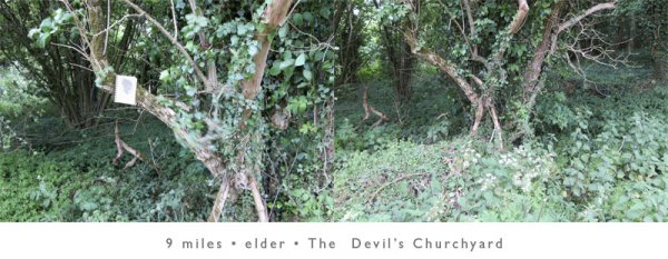
Via Slad Valley, Toadsmoor Valley, Stroudwater Canal, Chalford, Hyde, Devil’s Churchyard, Cherington,
19.4 miles
Beech, Lime, Oak, Holly, Elder, Field Maple, Elm, Sycamore, Walnut, Larch, Hawthorne, Ash, Cherry.
As the walk begins we become aware of the effect that stopping every mile to take tree rubbings will have on our progress. Stopping marks our progress, make us stop and take note of our surroundings and in particular the selection of a specific tree. They also allow us to reflect on the genius loci (the spirit of the place) and to take something of that unique sense of place progressively with us on our journey.
Day 2
Tetbury to Little Sodbury
Down the MacMillan Way through Silk Wood at Westonbirt Arboretum and cutting across to join the Cotswold Way.
a dodgy pedometer recorded 13.3 miles
After a great breakfast at Number Sixty Five, today we look forward to rain on our walk to the cunningly named Little Sodbury.

in the pouring rain, wading through very wet oil-seed rape on what was supposed to be a footpath, Richard & Tom enjoyed getting even more wet.
Walking through Tetbury as the Wool Sack Races, Samba Band and French Market were setting up, in the heavy drizzle. We found ourselves with no reference points when following the MacMillan Way trail guide and decided to walk along the car-spray roads and tracks we knew to Westonbirt. Arriving at the Arboretum, we returned to see and photograph a specimen of Dawn Redwood on which we’d earlier done a project. By then very wet and after stopping for hot drinks we pressed on, regaining the MacMillan Way and following it across fields without footpath provision or clear signage to Luckington (where Tom had to leave us) and finally the busy A46. And here, soaked but near our destination of Little Sodbury, a car unexpectedly pulled up alongside us with the smiles and laughter of Lynn and Fred Chance, who were driving on their way from Stroud for an evening in Bath. Such serendipity.
Day 3
Little Sodbury – Elberton.
18.1 miles
Good to put away waterproofs and find a wonderful early summer day – so different from the previous day’s torrent. Leaving the Cotswold Way for a long section of the Jubilee Way, when we could find it. Housing estates and development had obviously taken map makers by surprise near Yate. Footpaths dissolved into unsigned suburbia as we added extra miles to our journey. We took to using roads and braving traffic, went past Leechpool, up green lanes lined with oaks, passing through more fields of rape, oats and maize. Parts of our route were treeless and so our ‘one-mile’ project had to slip while. Attempts at cattle wrangling when stampeding bullocks came to play grand-mother’s footsteps as we crossed their field. Our first view of the Severn and in the far distance, our objective for Thursday night – May Hill. Eventually to the A38 and the sprawl of Thornbury’s industrial estates. Odd how after spending time away from traffic, it’s noise and speed seems amplified. After finding our B&B we enjoyed another 2 mile walk to find a pub.
Day 4
Elberton to Park End
Via the Severn Bridge and Chepstow
21.07 miles
Dozing through dawn’s chorus at 4am, but eagerly anticipating reuniting with Tom for today’s walk high across the water to Wales over the Severn Bridge. Braving the road with no pedestrian paths and fast commuter traffic on it’s way to Bristol, we moved through a concrete ‘no-man’s-land’ towards the buzz of motorway traffic, the huge bridge and the crossing point into Wales. Here waiting for us on a high gantry was Tom, dwarfed by the huge structure that’s designed for transport, not foot travellers. He’s to walk with us halfway across the Bridge before turning to go back to England. We see the last tree in England, then high over the River on a gloomy and grey day walk the 4 km of the traffic-vibrating bridge. Looking down on the fast, brown tidal flow and then along the shore to the blockhouse construction of the nuclear power stations. Past soldiers chatting in their barracks below, we greet the first tree in Wales, street clutter and utilitarian urban design. Through barren social housing streets with sad looking people, past betting shops, fast-food and few green things. Chepstow’s old centre, castle has charm. The Bridge on the River Wye leads back to a ‘Welcome to England’ sign and a very steep climb up a cliff-side lagger.
With occasional glimpses through the trees, we see distantly back over our route – the Severn Bridge, the River itself and on it’s far bank, the ground we covered 2 days previously.
Again we were pursued by curious cattle, but guided by horses when the footpath signs were invisible.
Trudging through woodland and rough tracks that were once railways, missing yet more signs we emerged in Parkend and The Fountain. Glorious beer, glorious food and a comfortable room.
Day 5
from Parkend to Longhope and the Farmer’s Boy
16.63 miles or there abouts
Joined at breakfast by Tom, wearing new boots. Leaving the comfort of Parkend and managing to miss another track – taking an extra mile to explore old railway tracks and cuttings into the woodland. Entering the Forest of Dean in wonderful walking weather, we walked along tracks, up through natural, mixed woodland and formalised plantations of conifers. Wildflowers; foxgloves, late bluebells, knapweed, bugloss, toadflax, spurge and honeysuckle gave glorious splashes of bright colour against soft new-green light. A dog-fox passes, then returns not believing he’s seen us… only then he presses his ‘invisible switch’ and we’re left wondering if he was real. Making our own path across wheat fields, between old oaks. Dogs sometimes bark out a warning when we pass farm and woodland buildings, but settlements are few with only the odd house or church….certainly pubs or tea stops are rare. Fantasising about cream teas and when looking once again for the path that disappears, The Victorian Tea Rooms appears like a mirage. Salvation and salivation. Smart ladies of a certain age in a celebratory mood disembarking outside – one has a birthday and takes a shine to Richard’s knees. When the excitement dies down and entering the tiny garden, we’re met by a man in a chequered scarf who tells us the establishment’s closed.
Path rediscovered and thrashing through more nettles we disturb a fledging blue tit who perches on a branch and poses for photos, looking at us with alternate tiny black eyes.
A major navigational error lead down a glorious valley, through a neglected orchard with twisted trees. Rather than retrace our steps, climbing several hundred feet and crossing unmarked fields, footpaths are re-discovered. Where sheep shearers upturn bewildered ewes and close to Longhope, we discover the pub is another 2 miles further on.
Day 6
The Farmer’s Boy, Longhope, Under Mayhill via The Severn Path to Gloucester then to Edge
21.32 miles
Early morning, steeply ascending May Hill with it’s perky covert of summit trees. Fresh, damp, woodland smells and birdsong. Way up in the world at 296 metres we’re treated to views over the Severn’s snaking curves and the Welsh borders. Descending through pine scented woodland we see the Vale and in the far distance Gloucester Cathedral’s white tower. Legs get soaked as we cross fields still damp with dew. Then later, dust clouds of pollen form as we wade through grasses. Footpaths again dissolve into crops. Our one mile stops pass quickly and when we pause to make rubbings become a welcome opportunity to take shade. Lower, crossing railway lines to Chepstow and Cardiff we eventually make the Severn Path along the River’s high wall, through gates and over stiles that demarcate back gardens. Leaving the Severn we pass a parked helicopter in another back garden, before reaching the traffic sodden A4o and the final road to Gloucester and the Cathedral, where we’re to meet with Martin Large (rather later than we expected). Over Telford’s classic bridge and into the strange underworld of the area underneath flyovers. We walk onto a virtual island, through an area of urban countryside that was once the winter home circus travellers and contains Richard’s Wood. Suddenly spat out into traffic and having to cross the mayhem of busy roundabouts after several days of woodland track. Walking up peopled street and pass by shops, eventually close to the Cathedral that we’ve watched getting steadily closer for the past day. A late lunch and quick drink with Martin and then heading out of town, along Eastgate. Through one of the victorian and now ethnic suburbs and then rising up and passing estates, new builds, vets, nailcare, haircare, healthcare. Rising up and climbing steeply now, more stiles and footpaths, St Leonard’s Well and an old Roman way leads up through white flowered meadows to the top of the Cotswold escarpment at 225 metres. Above us still is Painswick Beacon and it’s Iron Age fort.
No need for maps now – Seven Leaze Lane and the Spoonbed Valley are home territory.
After a very long day’s walking, we’re just 2 more tree rubbing halts before we stop for the night.
Day 7
Edge – Folly Wood
3.68 miles